
“We know our lands have now become more valuable.The strangers think we do not know their value; but we know that the land is everlasting, and the few goods we receive for it are soon worn out and gone.”
Chief Canassatego
When the first European settlers came to what lloked like an inhospitable rock in 1629 they were not offered any other choice. The Spanish Admiral who captured the island of St. Kitts, then occupied by French and English settlers had come to rout out those peole from what was considered Spanish Territory. The only exception were the Irish slaves and the Scotish prisoners of war held by the English. The Irish because they shared the same Roman Catholic faith with the Spaniards and the Scottish who were prisoners of war. They were allowed to leave their villages of Middle Island and Palmetto Point on St. Kitts and find some other place to live. Saba can be seen clearly from St. Kitts and so it ended up that they came to Saba to settle.
Arriving at Saba they selected two sites above the Wells Bay which they named Palmetto Point and Middle Island. The villages were located on top of the cliffs which could easily be defended and the bay was good for anchorage of boats and the village were not far from the sea and they could fish there. The lands above Palmetto Point especially were good for small scale agriculture and from that time on private ownership of property was recognized.
The West India Company supposedly around 1640 sent some settlers from Sint Eustatius and they had a village above the Spring at the Fort Bay which was destroyed by a landslide in 1654. All Dutch historians referred to supposedly around 1640.
In 1665 Thomas and Edward Morgan uncles of Sir Henry Morgan came with a fleet of pirate ships from Port Royal, Jamaica to capture Sint Eustatius primarily and captured Saba in the process. Durig the 1665 incursion the English intruders summarily deported 250 Statians to Barbados when they refused to swear fealty to Charles II. The list of English spoils were fifty thousand lbs of tobacco, 300 head of cattle, 50 horses and 840 slaves which they transported back to Jamaica.
Saba was left with 226 English, Irish and Scots and the slaves were taken back to Jamaica as well. Thomas Morgan was the very first Administrator of Saba and that is recgnized by Dr. J. Hartog in his book “De Bovenwindse Eilanden”.
Furthermore some 90 pirates defected and remained on Saba as they saw it was an easily defended island, was a lot cooler than the sweltering heat of Port Royal. In 1667 Sint Eustatius and Saba were returned to the Dutch West India Company. The basis however had been laid for an English speaking people and then in 1672 the island was again taken over by the English and some settlers from St. Thomas were relocated to Saba as well.
With the increase in population and the need to expand the settlements so that they could survive from agriculture places like St. John’s which was settled most by Irish people with names like Windfield, Barnes, Dowling, Darcey, Kelly, and so on and they farmed in the mountain in small Rendez Vous.
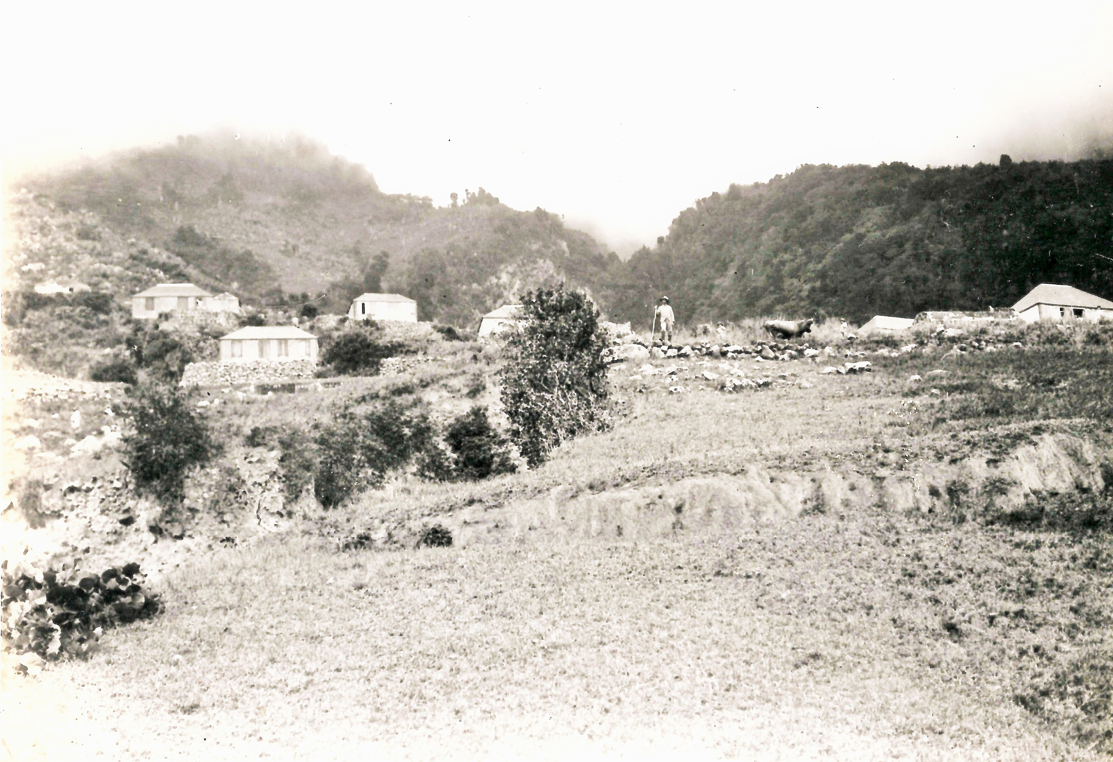
The Windward Side was first settled on Booby Hill for defensive purposes. Names like The Fort, the Brest Place indicate that they were the first means of defense for the sttlers in Booby Hill. The “pasture” in Windward Side was used by the settlers for common pasturage of animals. Names of settlers in this area were Carter, Keeve, Hassell, Kelly, Crossley, Johnson, Peterson, and also Simmons, Leverock, Every etc. They also later on took to farming Big Rendez Vous.
The village of Hell’s Gate was settled mostly by people with Scottish and Irish surnames. Collins, Zagers, Horton, Johnson, . They also were in close contact with the people of Palmetto Point and Middle Island with names like Beal, Horton, Simmons, Hassell, Collins, One indication of the Scottish place in Saba;s history is when the slaves were liberated (702) . in 1863, they were given mostly Scottish surnames. Like Wilson, Dunlock, Rodgers, Rose, Jackson, Scot,Rock, Jones, Maxwell, Boxwell, Watson but also Lynch, Hughes Riley which are Irish.
The town pf The Bottom was first called “De Vallei” by the sttlers from Sint Eustatius who built their village above the Fort Bay which had easy access to water. They use “The Valley” for their farming. The survivors and other settlers moved up to The Valley and started building there. After the invasion from Jamaica in 1665 and deportation of the Dutch settlers to Barbados, St. Maarten, the inhabitants after that were mostly ERnglish speaking and they thinking it was the bottom of a volcanic crater started calling it The Bottom and as time went on it gained in importance and became the capital of the island.
The most important families of European descent before 1863 were Simmons, Leverock, Bail or Beal, Wood, Dinzey, and names with a Dutch origin were van Beverhoudt, Cuvelje (French Hugenot), Graval, Moises Correa (of Jewish Origin on population list of 1715) Many of these families had moved on to the Virgin Island back then. After the Great hurriane of 1772 the petition signed for relief to the Dutch West India Company was for 90% the traidtional English names, like Hassell, Johnson, Cox, Keeve, Leverock, Simmons, Carter, Peterson, BeaksBaker, Mardenboorough, Halley, Every. Keeve, Kelly, Haddocks, Wood, Winfield etc. By then the island was settled and private land ownership covered nearly all of the island with the only possible government claimed land was a smal portion of the top of the Mountain.
The first Government owned land started at the end of the nineteenth century with government buying up some land in The Bottom, this contined into the 20th century, but all government land on Saba has a private ownership beginning and history whichcan be ascertained in the Government archives going well back into the eighteenth century.


On April 18th, 2016 a report “A NATIONAL PARK FOR SABA” For the Client “Ministry of Economic Affairs, The Hague was produced by Consultants Eco Vision. THere are flaws in the report. The main people who were consulted are not from here but who seem to be the main advisors the Government of Saba depend on and make decisions based on advice from these advisers not from here. In general the advice given is that Article 3.27 of the Civil Code could be used to claim ownership of the Park. According to article 34 of Book 5 of the civil code “Real estate of which no other owner can be identified, belongs to the Public Entity in which it is located.
Government policy however is to apply this rule with utmost reservation,because of the risk of infringement of property rights. Lands that have no owners are assumed to be owned by Government (civil law. book 5 article 24), however this must be interpreted with care since there may be private bills of sale which are not in the land registry.”
On July 18th, 2021 I had a lunch meeting with Richard Johnson and his wife Rita Johnson born Sagers. Both of these individuals who are in their eighties confirm that the land planned for a Nature Park was always privately owned. The lower part of the land known as the “Goat Cliff” and bounding to the sea was where the people of Plmetto Point and Hell’s Gate kept their goats. The upper part going up to the top of The Mountain was used for planting, tannia’s. bananas “Banana Gut of Ben Horton), also sweet potatoes, small or Gunea corn, eddoes and dasheen , pigeon peas, pumpkins,cassava, you name it. The land was very fertile in the upper parts.
Richie himself owns land by a place called “The Water Rock” by the “Mountain Hole” close to “Sandy Cruz”. His father in law Oliver Sagers now deceased owns land below the lands of Daniel Johnson by the “W hite Cliff”. William James Johnson known as “Jimma” father of Peddy Johnson and others used to farm Daniel Jhnson’s land, as Daniel was his uncle. Jimma’s brother also named Daniel used to work his uncle Daniel Johnson’s land by the “Lay Hole”Dudley Johnson, another brother owns a piece of land called “The Gray Bush” located more toward Palmetto Point or “Mary’s Point”.
In the “Ghaut” Peter James Johnson (Bernard, Ethel and Elmer Johnson’s father) owns a piece in Mastic Gut and Daniel Johnson also owns a piece of land there.
A piece called the “Cistern Patch” belongs to Captain Charles Reuben Simmons and I found a copy of the bill of sale in the Public Regsters of the nineteen thirties.
“Ouw” George Rodney Johnson owns land above that of Charles Reuben Simmons, and Oliver Sagers’ land is located above that.
“Ouw” George was George Rodney Johnson whose wife was Sarah Elizabeth Vlaughn (or Vlaun). They lived Behind The Ridge and are buried there. A person from the Unted States who bought their house built his patio over the remains of the graves but I know the location of their graves. Richard Johnson said that “Ouw George: owned much of the land over there. Among his children were Daniel Johnson and Henry Johnson both of whom worked the ground over there.Henry lived at Palmetto Point and was married twice and had a lot of children.
One of the sons namely Henry worked out Ben Horton’s Gut which is located next to the “Down Gut” and planted Banana trees there up to the “High Cliff”. I remember in an interview with Mrs. Rebecca Levenstone-Jones, she telling me that before one of the hurricanes she had bought a bag of bananas from Henry Johnson at Palmetto Point and theybananas were from “Ben Horton’s Ghaut.”
From early one land was being sold in the area between the Wells Bay and Hell’s Gate. I will give a few examples of transfers of land in that area of the island.
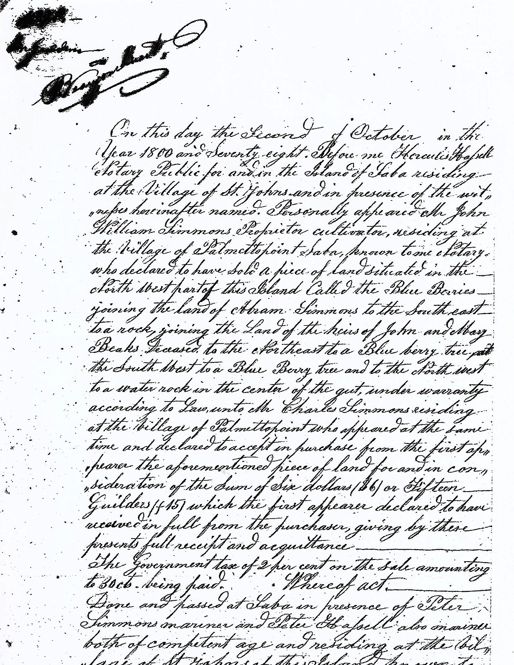
At a Vendue sale of May 25th 1869 the following is recorded: “Received of Mr. Thomas Beale the sum of $88.1 (Spanish Dollars) in full for the sixth part of the Goat Cliff frm the High Hill to the Red Cliff at “All too Far”. Signed John M. Dinzey Saba April 28th, 1805. Vendue Master. Exhibited and reorded this 6th day of August A.D. 1869. The Notary Public,Hercules Hassell.
In a statement #110 of 11/6/1869 the following declaration was made: ” We further declare that the Ridge known as “All-too-Far Ridge is situated to the West of “Red Cliff”, and that “Red Cliff” is opposite to “Green Island” and that there is but one ridge known as “All-too-Far Ridge”. witness: Peter Hassell, James Horton (Jr.).
Another document #116 of 13/7/1869 states the following; “Mr. James Horton sold to Mr. John Johnson one sixth (1/6th) of the “Goat Cliff’) from the Well to “Smokey Gut”. witnesses Henry Hassell and Peter J. Hassell.
On December 14th, 1896. Mary Peterson Dowling sells toWilliam James Dowling mariner at St. John’s “land at the Blue Berrries.”
In a document #11 of July 31st in the year 1920 in detereming the bounds of Charles Simmons of “Mary’s Point” a reference is made to the aforementioned sale of December 14th, 1896 in this statement.
” Second.-“Yankee Gut” bounded on the North side by the “Goat Cliff”marked by a “Rock” on te East adjoining “lands of St. John’s People’, on the South by the “Yam Ground” owned by Thomas Sagers and on the West by the Cliff.”


This bill-of-sale not only shows that Saba had a government but one that functioned, Even though the original settlers may have been pirates the Island of Saba was ruled according to International Standars of Law at the time. Saba had its own elected officials to assit the Commander of the Island,all native to the island. Saba had its own Court of Law which was comprised of all native Sabans, its own local Judge, its own local Notary while there was an appeals Court on St. Eustatius. In 2021 Saba is dependent on lawyers not from here as their advisors and seem to hestitate to ask locals for advice. Saba is now dependent on consultants not from here who do not know one cent worth of our local history and or would be historians who do not believe in oral history nor did they know the people and the hardship they went through to survive on this our beloved Saba.
On September 18th, 2018 the Island Council of Saba consiting of 5 Members voted to take away private owner rights to the descendants of those who owned the land and are covered with documentation to prove ownership. Three of the Members of the Island Council voted in favour and two voted against this decision of the Executive Council.
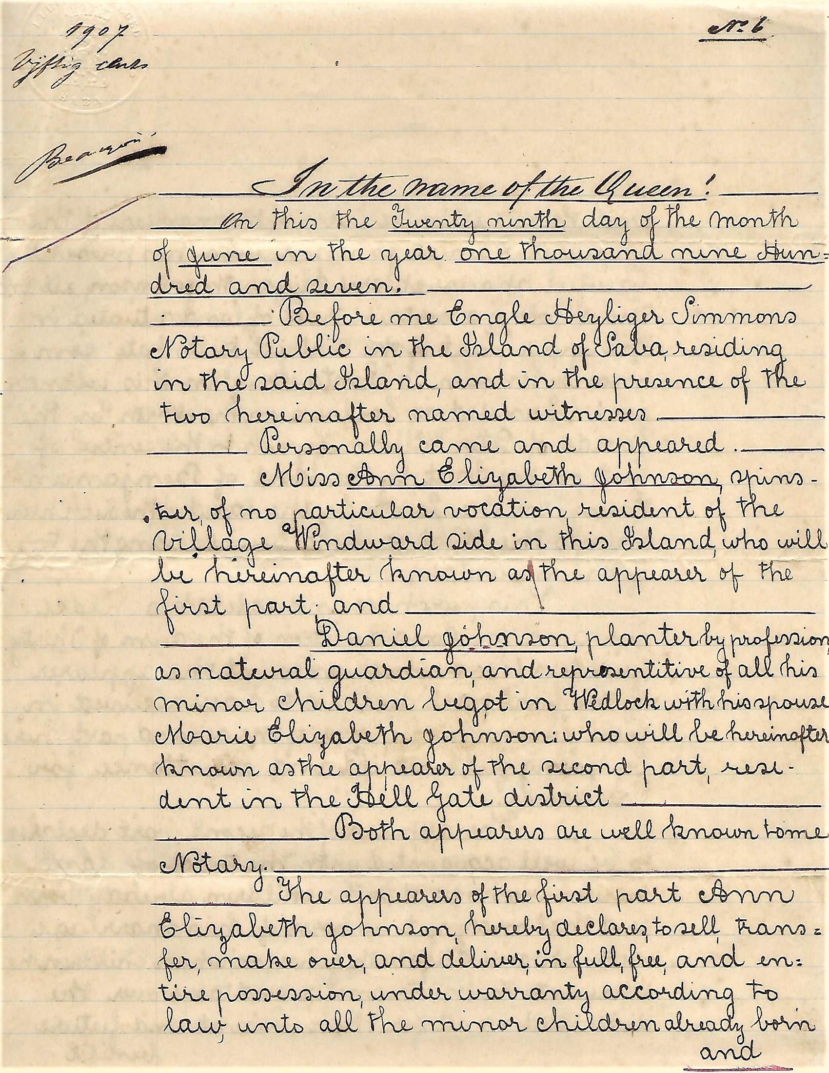
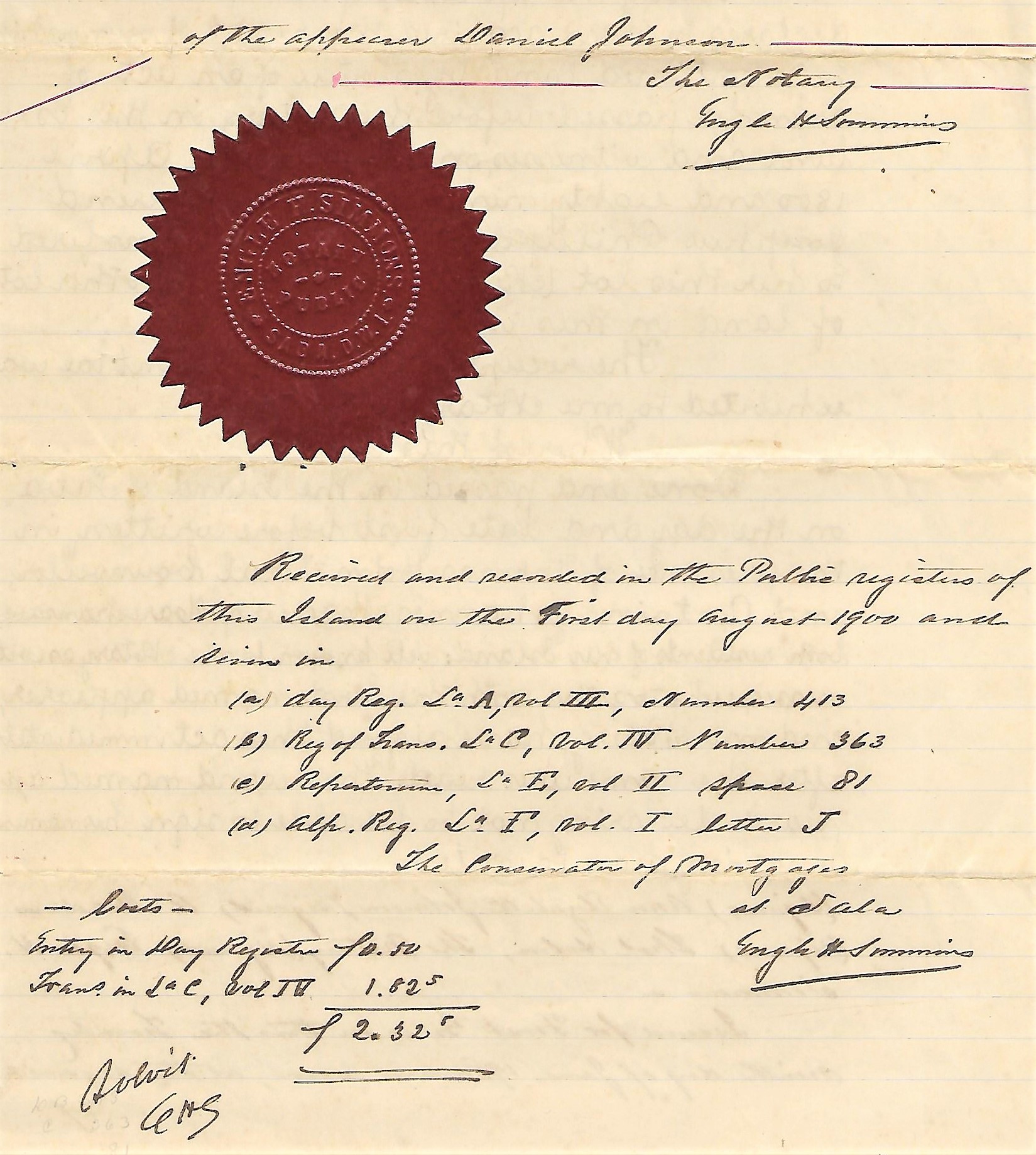
When learning of this decision I immediately sent a letter to the Executive Council on behalf of the heirs of Daniel and Marie Elizabeth Johnson to protest this decision. To this date I never got a reaction to my protest. There are many people on Saba and elsewhere who are descendants of the original owners of this land. Government never owned any land on the part of the Island which in effect has been stolen from the owners. The only land the Government acquired was from the last residents of Palmetto Point in 1935. Those who were forcefully displaced and moved to The Bottom and to Hell’s Gate were given small plots of land in the so called “Promised Land” . I will be writing a seperate article called “The Tears for Palmetto Point”, in its last few years fondly called “Mary’s Point”
I will be engaging legal advice on behalf of the owners. The Government still has the chance to change their decision and which was not based on the Advice of the Ministry of Economic Affairs in The Hague. On Saba in recent years large sums of money have been paid to private investors by the Government of Saba. In 1990 the Government of The Netherlands made nine million guilders available to buy Small Bonaire from foreign investors to establish a Park there.
I want to find out why Saba landowners are losing their land without compensation and are told that they cannot effectively use that land anymore.
If you feel that you are an heir to any of the land which has been declared a National Park then please come forward. The principle landowners of the past are documented in my researh. People who are descendants of James Horton, Daniel and Marie Johnson, Leonidas Johnson, Henry Thomas Johnson (father to Effie Hassel-Johnson, Dudley Johnson, Ellie Hasselland a number of others), and anyone who has family documents which can prove ownership of that part of the island please come forward.
I have assembled enough documents to engage a law firm to take this matter to Court. I will do so as soon as I can find a lawyer who is not compromised by being on the board of government owned companies and/or otherwise indbted to government so that the Saban landowners being dispossessed will get a fair hearing.
In the meantime I remain,
In duty bound shall forever pray:
Your humble servant
Will Johnson
