Account of a visit to Saba from February 13th to February 16th 1829

The fourth and final part of the book by M.D. Teenstra of his visit to the Island of Saba in 1829.
Martin Duwes Teenstra Visited Saba from Friday February 13th to Monday February 16th 1829.
The Fourth Chapter of his book “De Nederlandsch West Indische Eilanden” Curacao, St. Maarten, Sint Eustatius; Saba.
In 1837 the publishing house of C.G. Sulpke published “The Dutch West Indian Islands in their present day state.” Written by M.D. Teenstra.
About the Author.
From the Encyclopedia of the Dutch West Indies, and reprinted by S. Emmering, Amsterdam (1981).
Teenstra (Marrten Douwers) born in Ruige Zand on 17th Septemer 1795, deid 29th October 1864 at Ulrum, practised arable farming in the Netherlands in his young days but not successfully.
In order to retrieve his fortune he went to the East Indies around 1825 where he would not be successful either. Shortly after his return to Holland the Dutch Government sent him to Surinam as an agronomist in 1828, when Van Den Bosch commissioned him to explore the riches of the forests. He became a president of agricultural society “Prodsse Conamur” founded May 16th 1829. Shortly after his arrival he was appointed superintendent of Bridges. Roads and Hydraulics in Paramaribo, and state cultivator.
He visited the Dutch West Indian islands in 1828/29 and 1833/34 returning to Holland in 1834 after holding a post as a senior clerk at the registry of the Court in Surinam for a short time. He was well known when alive as he wrote quite a number of books including one on South Africa where he stayed for some time after getting ill on his way to the East Indies.

The Fourth Chapter of his book covers the history and his visit to Saba.
Location
Saba lies 5.5 geographic miles W.to N. of St. Eustatius, 8.5 miles S.W. of St. Barth’s, and 7 miles S.W. to South of St. Martin. The village in the middle of the island lies at 17-29 Latitude and 63.19 Longitude.
Chapter 2
Size and Shape
Saba is only 15 miles (*) in circumference and 18000 acres in area (+)
- Miles of 1760 Igards, the Igard of 36 Rhineland inches.
- (+) An acre is 4860 Tjard or 302.5 Rhineland rods.It rises as a barren rock very steep out of the sea, and presents itself from some distance as a single mountain, and can be seen from a distance of 15 geographical miles. To the North West side, there rises at a distance of a gunshot from shore, a high and very steep, needle shaped rock, called the Diamond.

S. and S.S.W. of the island there extends five and three quarter miles from shore, a reef or bank, on which there are 12 to 17 fathoms of water.
At four English miles distance in a Southerly direction from Saba there is a small embankment of shallows, which is covered with water 3 or 4 fathoms and where the sea breaks with tremendous force, when there are strong winds. People believe, that in 1794 an English vessel , going from Jamaica to Martinique, was shipwrecked on these shallows. The exact location of the vessel in question is not known.
In the late afternoon watch of February 6th, 1834 we sailed with the “Echo” over that same area, measured on same, 7.5 fathoms of water, then 9, 10, 11, 20, 25, 30 and after that with 40 fathoms there was no bottom. When we had the highest point of the middle of Saba, N1/2W. and the N.W. corner of St. Eustatius N.E. of E., behind us, we were on the rim of the reef, and the water became a darker colour. This bank which is 100 to 120 Rhineland rods wide, consists of irregular coral stone, of a white and black colour and grey rocky grit. One finds the same noted on the chart, of Noiri, but at larger depths.
Mountains and Valleys
Chapter 3.
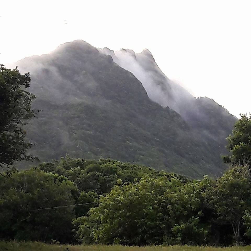
The mountains are unusually steep, and only here and there some pasture for the livestock. One can consider the entire island as a single mountain, with some valleys. The highest top is called The Peak and it has an elevation of 3330 feet above sea level. The houses of Chrispeen are 2430 feet, and the church in The Valley rises 1680 feet above the same sea level. The most important valley is called The Bottom, and has besides the mentioned Church some houses which together are called The Village.
Rivers, brooks, bays or harbours are not found on the island. There are three fresh water springs, and five hot water springs. Drinking water here must also be collected in cisterns, which, when they are dry, also serve as prisons.
There are here only two landing places to be found, Fort Road Stead to the South, and the other, which is the most important one, named The Ladder, lies N.W. to N. of the village. It was here that the pirate ship, the swift sailing schooner “Governor Dorego”, under the Command of Alexander Beriteau, being a vessel of Buenos Aires, together with the Brazilian prize ship “Lebre” , were anchored, when both were captured in April 1829 by his Majesty’s Man-o-War “De Valk”,Commander Van Es, and taken to Surinam. *
(* The pirate Captain Bariteau was condemned by the Court of Civil and Criminal Justice, of the 29th of September 1830, to twenty years of forced labour. The second person Stevan Donay to 15 years; Manuel Echanis and Charles Stuart both for three years, while Eugene Gouvernon as besides the rest of the crew were absolved and set free.)
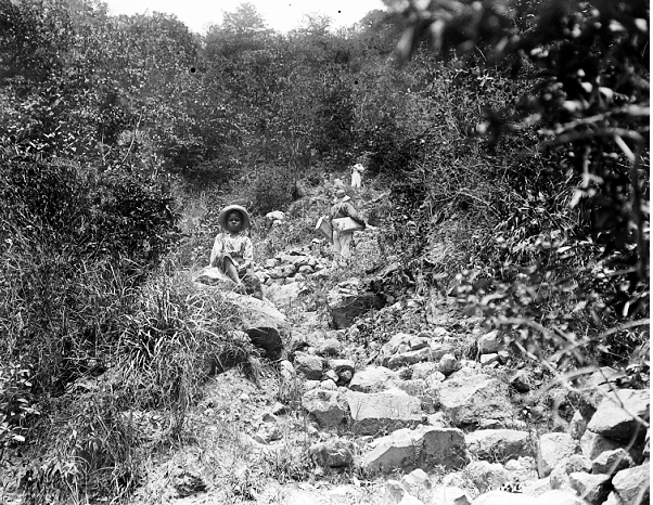
The roads or rather the paths, which lead from the said landing places to the valley are extraordinarily steep and difficult, and each almost an hour long going, thereby so narrow going up between frightening chasms, that no two persons can go side by side. Everything which one wants to carry up or bring down must be carried in small quantities from or to The Valley, and borne with difficulty.
The blacks however bring with great skill, on their heads, down the hillsides, the frames of boats, which are then built on the coast, which the stranger, had he not seen it, would have considered it impossible to do.
Chapter 4.
Districts.
The island is divided in six districts whaich are named Palmetto Point, The Valley, Chrispeen, St. John’s, Hell’s Gate and The Peak. Also here from the middle of July until the middle of October one has to deal with the frighhtening hurricane months. Normally they come from the North, and follow the compass in a Westerly direction, back again in the North. Very seldom however they last for more than 24 hours without a pause. Not withstanding that the Peak, except in the month of February is without clouds, there is less rain than the inhabitants would like to have.
Epedemic diseases are satisfactorily not known here, which is attributed to the refreshing sea breezes. On the entire island there is no medical doctor, why it is to be wondered,how the people become old, and the population is increasing. Only very few lepers are to be found here, and the Jaws and Elephantiasis are not known here at all.
Chapter 5
Village and Fort
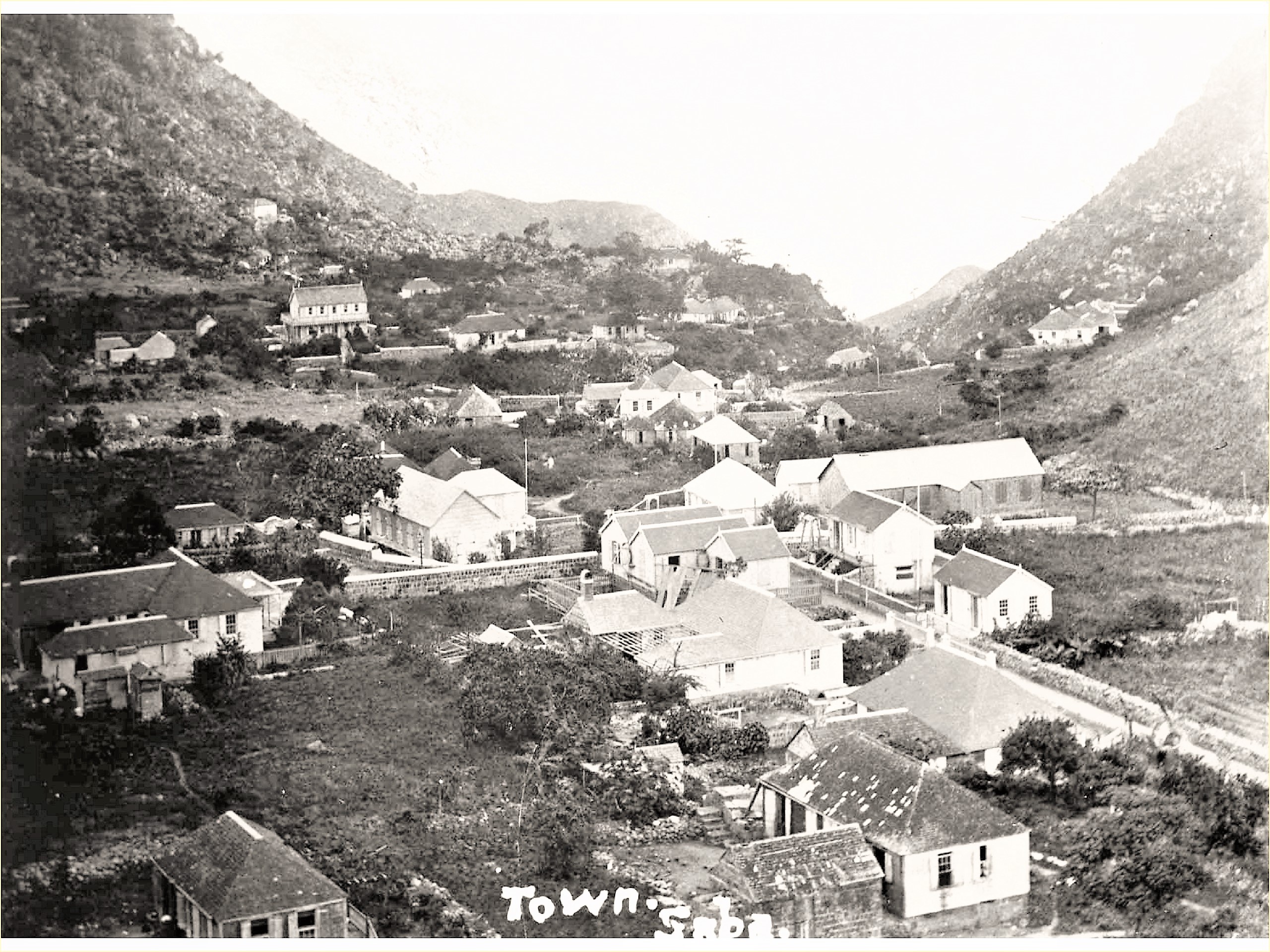
The houses are spread out in The Valley, named The Bottom, are, considering there is a church in their midst, called The Village not withstanding that the area called Windward Side has the most houses.
The only religious leader, who lives here is a Prebyterian. Methodists are not tolerated here. The church building after the hurricane of 1772, has been completely rebuilt, for which a collection was taken up in the neighbouring islands. In 1821 it was repaired and noticeably improved. It is not large, an oblong square building, of which the massive walls are built of stone. The same also serves as Council Hall and school.
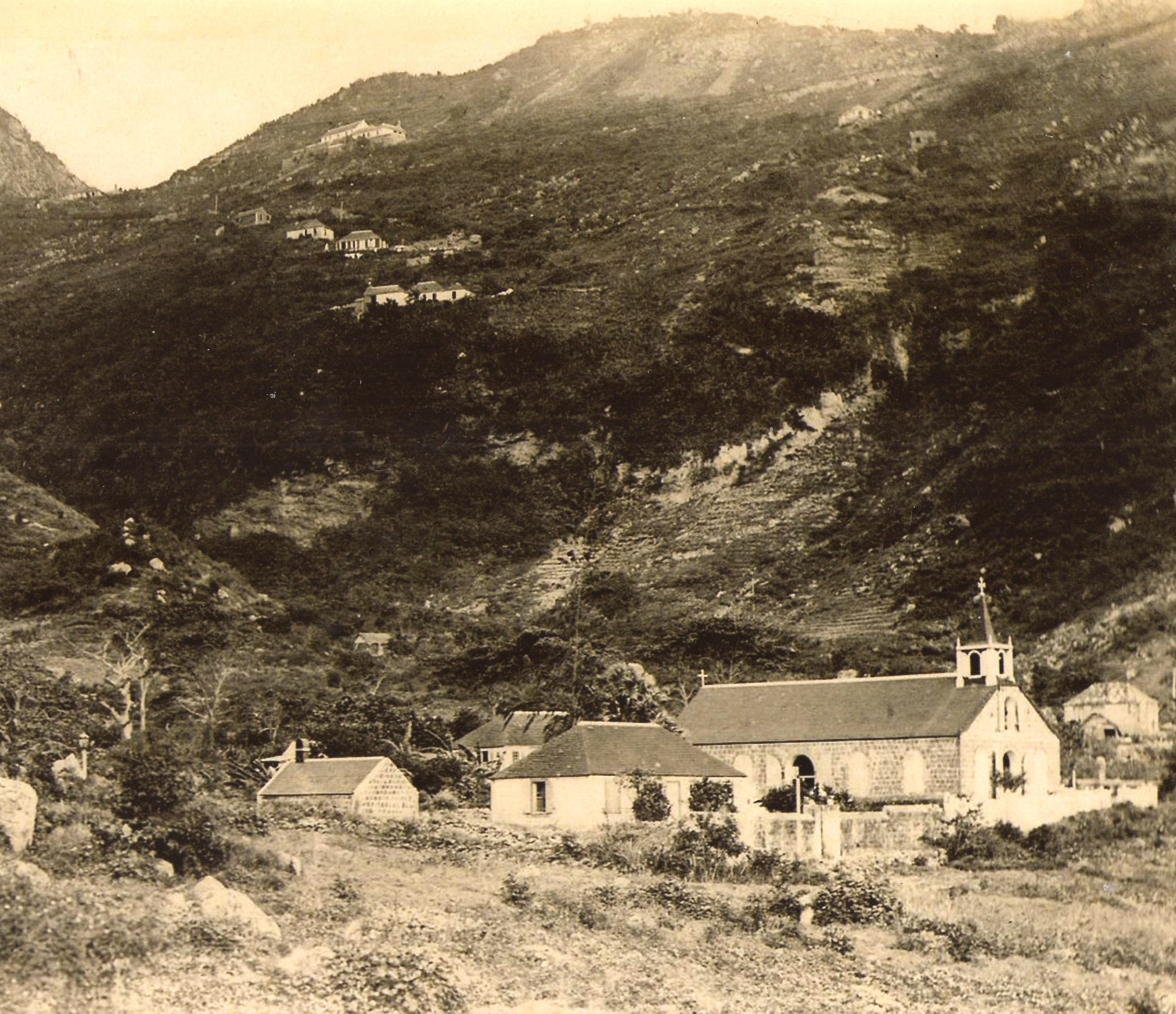
The houses in general are not large, but are maintained in a clean and well mintained condition, and not to be exempted, the straw huts standing in between, with their gardens and front yards. There are nowehere piles of rubbish, and houses in disrepair, by which Paramaribo, St. Eustatius and St. Maarten are so poluted,
Chapter 6
Defense
The Southern part of the island is called the Fort Bay, one can only find there nothing else but four useless canons. There are no military forces here, but the citizens are good marksmen, and the reverse, the same insignificance would be besides the least bad weather, sufficiently inacessible’
Chapter 7
Means of Existence

One finds here only a few small sugar plantations, which are located at The Bottom, which belong to a cetain Dinzey [Thomas]. They have between 20 to 25 acres under cultivation, and a slave workfroce of 60 people, but of which half of them are children. The yield is completely dependent on the more or less extent of rain or drought. The harvest of 1828 amounted to 150 barrels. That of 1829 is anticipated to be not more than 30 barrels.*
(*American flour barrels, containing sugar of between 230 and 240 pounds Troy).
Each home, people calculated, that there are, besides some straw huts, 150 which have its own garden planted with sugarcane and cotton, besides some bananas (Bacova’s) . In the mountain ravines, one can find some very luxuriant and fine quality coffee trees,and on the slopes of the mountains, some corn and a larger quantity of Guinea corn.

Every home of some importance has a sugar cane handmill, consisting of two horizontal cyclinders, which are turned around against each other by two blacks. The women who plant the cotton, make their own spinning wheels, and knit very fine socks and gloves, which are lovely and strong. For the first I paid six, and for the latter, eight guilders for a dozen.
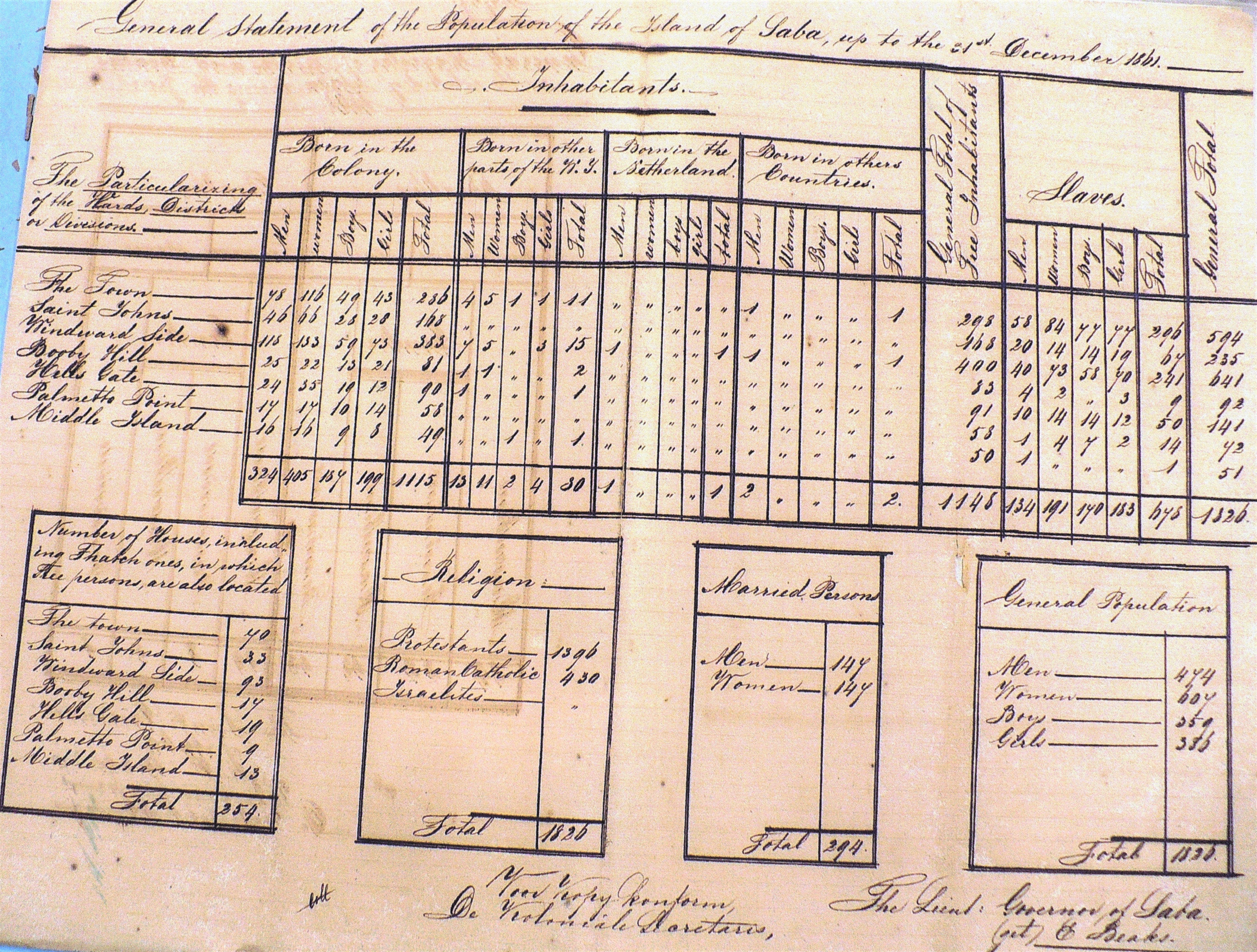
According to a report of the Governor Cantz’laar, the livestock in 1816 consisted of 1 horse, 8 mules, 191 head of cattle, and many sheep and goats. In 1829 there were here 3 horses, 5 mules, 150 head of cattle, 300 sheep, 800 goats and 600 pigs, among which there were found some weighng more than 300 pounds.

Poultry and “pulputanen” are plentiful, but no ducks or “doksies”. Garden vegetables are here also plentiful such as tubers, potatoes, and other ground vegetables, as well as cabbage and other greens. Bread is baked from cassava meal, which is more
dry and healthy than tasty and is nutritious. If the agriculture and raising of cattle are not profitable any more, than is necessary for local consumption, there is some export to St. Thomas, also trade is very small. The men, a great deal of them fishermen catch a great quantity of turtles and other kind of fish,which they take to other islands for sale, while also on this island excellent and very much sought after rowing boats are built. The women spin and knit different pieces of cotton clothing, while further export exists in the export of some cattle and garden vegetables. The entire export of the mentioned articles is restricted to barter trade with St. Thomas from, of which pieces of clothing, shoes, hats, (on Saba there are neither tailors or shoemakers), salt pork and meat, cotton, coffee, wine and distilled, which in trade are received back in return.
Import duties are very small, and as well as a reult of this, as to the limited import, is the levying thereof of particular little importance and can amount over a whole year period to hardly f.80.–
Chapter 9

Government
The Commander of Saba carries the title of Vice Commander who is assisted by three or four civil servants, and he is responsible to the Commander of St.Eustatius. The present (1829) Vice Commander of Saba, Edward Beaks Jr. , a native of the island was recently dismissed from his position and replaced by Mr. Richard Johnson, an old man age 72, who never went on a boat, much less any foreign region, and even had not set foot on any of the neighbouring islands.
The Council of Policy, consisted of:Messrs. Richard Johnson, President
John Dinzey Winfield, teacher and merchant
Henry Johnson Hassell , member
Henry Hassell, member
Charles Simmons, Secretary
John Davis, Marshall and Postman,
Moses Leverock, Vendu Master.
The only tax levied on the island is for the income of the Vice Commander which amounts to f. 800.– per year, It can be provided from the incoming duties, from the income from the tax on sales and from some scarce emoulements. If all of this amounts to the aformentioned sum, then it is to the benefit of the Vice Commander; if however it is less, then the shortfall is charged to the inhabitants. The Secretary has no other compensation than the benefit of some emoulements, which can yield around 100 guilder per year.

Chapter 10
Language, Morals and Customs
The language used here is a dialect English, and not one resident understand a word of Dutch. Although in general poor, the inhabitants of Saba live among each other very peaceful and harmonius, for which is proof when the take over of the island in 1816, not one case was brought before the Judge. For such much is contributed by the common marriages, whereby nearly the entire white population are related to one another. The natives are so attached to their place of birth, that when they go else where even if it settling on one of the neighbouring islands, they die from homesickness. The emigration to St. Eustatius has been done succesfully sometimes by some with good results
One claims that the women of Saba are the prettiest of all of our West Indian possessions, considering that they are well shaped, white and with blushing colour, have a healthy European appearance. The abbot Raynal, ( and who dares to doubt the witness of an abbot in such matters.*) “Throughout America there is no blood so pure as that of Saba; the women there preserve a freshness of complexion, which is not to be found in any other of the Caribee islands. “
- A philosophical and political History,of the settlements and trade of Europeans in the East and West Indies X Vol. by the Abbe Raynal. Vol. V page 423
- For myself, I find the women of Saba more amicable than handsome; in general they are more gentle in nature, and domestic.
- The slaves are treated here with special humane care. and hardly feel their enslavement. Also with regards to foreigners, the inhabitants, the natives, practice an extraordinary amount of hospitality,and although their language as has already been said is a bastard English, they are however far from prejudiced against the Hollanders, as are the inhabitants of St. Eustatius. In general as well as their simple lifestyle, as their morals and customs are all praiseworthy

Chapter 11
History
Saba was discovered by Colombus in 1492 on a Sunday or Sabbath known by the Spanish Domingo or Saba, which island was unihabited at the time. People claim that the first population consisted of emigrants from Sint Eustatius and St. Kitts (* Hollanders, Scots and Irish, who settled here in 1665) and in the beginning cultivated a bit of cotton and coffee, and later on also sugar, while some things were shipped via St. Eustatius to Holland.
When I said before that the island is strenghtened by nature, by the same narrow, steep and difficult to climb mountain paths, the French who sought to capture the island by surprise, experienced this to their loss. The islanders defended themselves by rolling down boulders, whereby the enterprise failed completely. The terrible hurricane of 1772 nearly destroyed Saba. Besides the church 100 houses were destroyed, coffee and cotton trees were carried into the sea and the land was made barren by the salt spray falling over the island. This led to bitter poverty and to the moving of some of the inhabitants elsewhere as a reult. Since then the coffee and cotton which was cultivated here was not sufficient for their own consumption, and that which is lacking is imported from St. Thomas. Also the hurricane of 1819 did extensive damage here, although in less measure than to St. Martin. Of less importance was the hurricane of 1821.
Chapter 12.

Animals, Plants and Minerals
The animal world has nothing noteworthy on this island. Only in the hurricane months, one can find some wild doves. Vermin and insects are here just as abundant and of the same sort as at St. Eustatius.
Besdes the plants mentioned by us in our report on agriculture, one can find in the mountain gullies, in the fertile ground which is difficult to plant in, some cocao and coconut trees and some quantity of Vienca’s cactusses and Aloe plants.
To the Eastern side of the mountain there is a well of perhaps more than 3000 feet depth, or to the surface of the sea. A stone thrown in there cannot be heard falling. Formerly arsenicum (rat poison) was found here, but the fear that the blacks would misuse this, kept the location from being disclosed, and now it has been completely lost.
In the mountain of Chrispeen, there is a cave, in which there is white chalk, sulphur and plume alum. Also on top of the mountain one can find two such mines, which the trouble and costs which would accompany the exploitation, would not compensate for the slight income it would generate.

Chapter 13
Excursion to Saba
Finally some notes follow which were made by me, in my Journal about a small outing to the island of Saba. I hired for that purpose the same Captain Flaun (Vlaun) and the same sloop, with which before I had sailed to St. Eustatius. We agreed that he would take me to Saba and wait there for two days, after which he would take me back to St. Martin for which I had to pay him twenty guilders, while I would provide myself with food and drinks.
On Friday morning on the 13th of February 1829 I left St. Martin for this trip, and I was accompanied as a travel companion by Mr. A. D. du Cloux, commander of the detachment of riflemen in garrison there.
At 8 am we sailed with a stiff North Easterly cool wind out of Great Bay
and arrived at 1 pm on the South West side of Saba, at the Ladder, at anchor, a miserable landing place. Very wild and barren, the island presents. When sailing around the West side of same, we saw outside of Mary’s Point, the naked rock called the Diamond, rising out of the sea. At 15 fathoms deep it stands completely by itself like a tower 90 feet above water. The breaking of the sea is terrible, as well as on this rock, as on Mary’s Point itself, which amazing steep coast is surrounded by blue and read rocks. Above these rocks one can see on the steep incline of the mountain some humble huts and small houses located there, which neighbourhood bears the name of this point.
***( This needs closer inspection.. Teenstra is referring here to what is called Torrence or Torens Point as “Mary’s Point with the village above on the slope being called by the same name. However the area is being referred to in his story as Palmetto Point, which would include Middle Island and Cow Pasture assumingly. Perhaps this was because the village of Palmetto Point was the most important of the three. Teenstra would have been unaware of the first known map with few details made by Captain E.H. Colombie of the Royal Navu dated 15 April 1816, the year Saba was transferred to the Dutch from the British. The cartographic story of Saba is even shorter. The first map of the island was made by the British Naval Officer E.H. Colombine and printed by the British Hydrographic Office in 1816. No new printed map of Saba was published until well into the twentieth century. The island did appear as an insert on several British maps and on a Dutch nautical chart from 1903. Around 1883, another printed map of Saba must have been published, but this one is known only to us through later copies. Close to the end of the nineteenth century, a manuscript map was made of the village known as The Bottom. In a census of 1861 made by Governor Edward Beaks Jr. the village is clearly referred to by its original name “Palmetto Point” and I have bills-of-sale even in the early twentieth century referring to the seller of the property as residing in Palmetto Point. Could the point have been known then as “Mary’s Point? And if so where did the Naval Officer have got the name “Torrence Point” from. This map of 1816 set the trend for all future maps to refer to it as “Torrence Point” but someone in 1829 must have told Teenstra that the Point of Land opposite the “Diamond” was called “Mary’s Point:” Also in the census of 1823 just six years before Teenstra visited Saba among the names mentioned are those of the heads of households of Palmetto Quarter among them my great-great grandfather and my great-great- greatgrandfather who lived between St. Eustatius and Saba. The list of heads of households for Palmetto Point Quarter was James Horton Sr. and his son James Horton Jr. , John Beal, Peter Simmons, Peter Hassell, John Zeagors, Thomas Zeagors, Peter Collins and James Hassell.

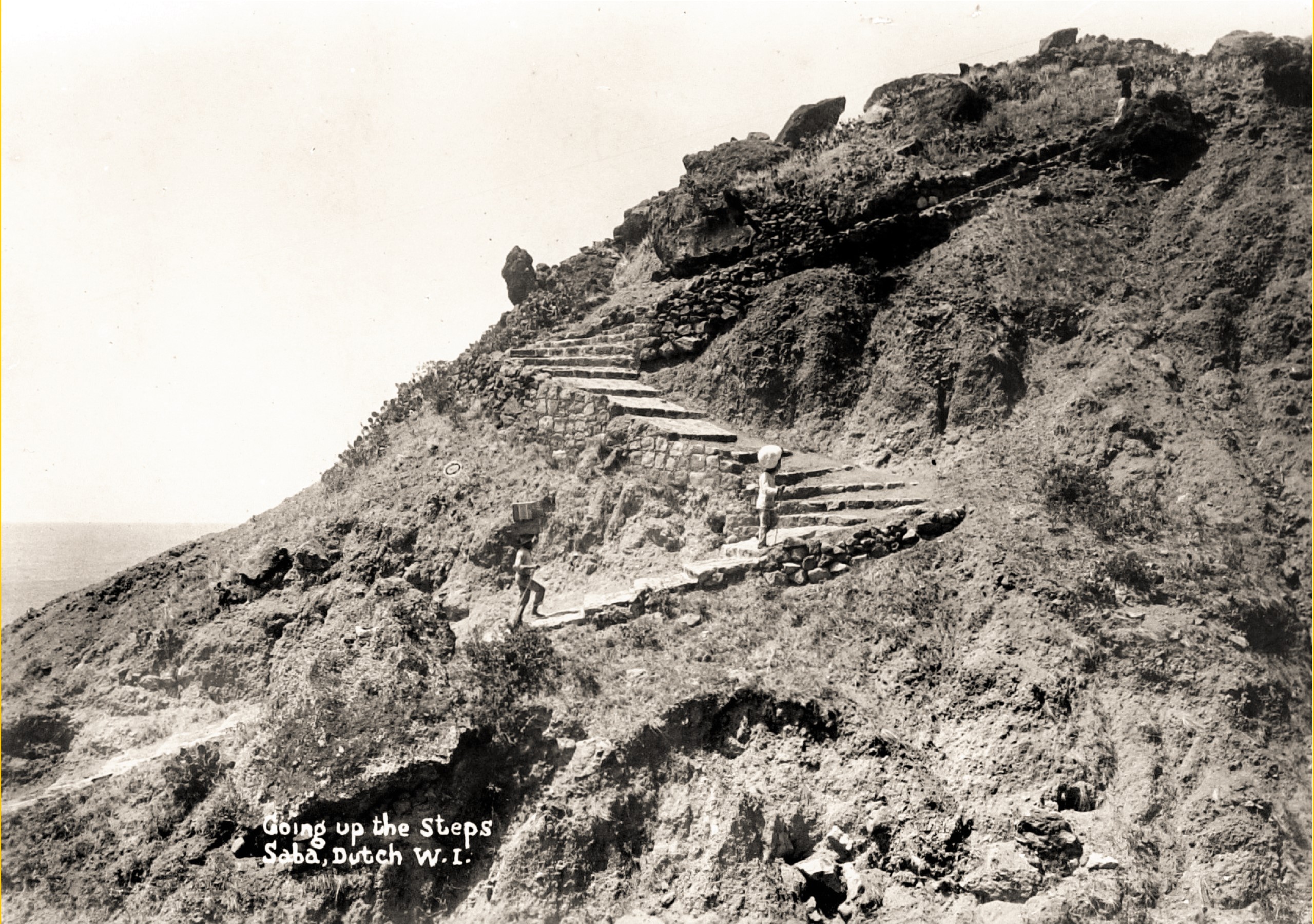

Sighing I looked up against the steep landing place, and wished from the depth of my heart, that we could already be on the top. If before this time.I was of the opinion that the landing on St. Eustatius was difficult, there is no comparison to be made with the landing at this island. There is no Bay, and the small flat embankment, at the foot of the steep mountain consists of some “vlenten” , or rather round washed up balls and rolling stones, on which there was a high surf present. And after this dangerous landing, the most difficult part of the voyage first begins. With every right the mountain path bears the name of The Ladder because along an irregular formed path of steps, one has to climb to the top. nearly 1700 feet to “The Bottom”, ( Icannot understand. because one must actually, with every effort of force climb for a whole hour before one has actually reached The Bottom). Added to that the late afternoon sun, shined so terrible, and I do not need to say this, that in the sweat of our faces we reached the object of our trip.
At last we were at the top and entered into the large and fertile valley, of which the glorious green, provided a most surprising contrast, with the surrounding naked mountain top. It has two exits, one which leads to the Southern shore, the other to the Western shore. That Saba was a burning mountain, is so evident that such leaves no room for discussion, and it is probably, that this so called Bottom at the time was the crater.
Hardly had we arrived in between the 40 to 50 houses, and looked forward to seeing one of Saba’s so highly f amous beauties, then as if to restrain our desire, the first woman who came limping was so hideously misfigured that she could be an example of all that is ugly, and that immediately when seeing her face, I thought on, that which our Father Cats so accurately described witch came to mind.
W hen we arrived at the Church we were welcomed by the most important inhabitants, who were of the opinion, that we were charged with a most important mission; while they with anxious curiosity tried to uncover the reason for our arrival.
Entering the church we met Mr. James Dinzey Winfield, Member of the Council of Policy,busy in his capacity of teacher, giving lessons in English to some fifteen students, because Dutch is so strange here, that no one even understands it.
We proceeded after that with Mr. Edward Beaks, the former Vice Commander, to his residency next to the church, where we were received exceptionally friendly and with generosity.
I, who had imagined that Saba only had an impoverished population, in civilization half a century behind, experienced, and discovered here that I was deceived in my expectations and for the good.
The house was clean, and expensively furnished, and the food which was served to us and drinks in abundance, and extremely delicious.
After we had consumed a grog od delicious old rum, our wih was to go to bed early, so as the following day with the pleasur of the cool morning to climb the mountains and to see Saba up close;but going to bed was postponed with one cigar after the other, followed by more substantial drinks.

Because of that a late awakening and some discomfort, I decided to remain another day, which increased the costs of the voyage considerably, as my good friend Flaun (Vlaun), kept himself to the quote; Everyone fishes to his own tide.”
It was already 9 am, when we started out to the East towards the mountains, to climb the 750 feet higher than The Bottom situated Chrispeen; the path leading there follows a winding and rocky mountain path.
The view from there down on the village is picturesque, while because of the strong echo of the noise from below you can call out to anyone. From this height, where it was rather cold, you can see St. Eustatius lying, which from that location seems very close. The living colour of the pastures, which are found here, and on which very good grass grows provides for a very charming view. We wander now from this green slope, downhill, along a veryt narrow and dangerous rocky path, to Windward Side, the residence of Vice Commander Richard Johnson.
This narrow and curvy path which winds halfway up the mountaiin, around deep ravines and steep chasms, is everywhere horrifying. Looking jp to black split cliffs and crumbling huge rocks, which because of the passing clouds appear as falling down, while the wide gaping ravines, the deep chasms, and the broken off mass of rocks, already below, cause the hiker to shudder.
We now heard the call, HELLO, AWOOI, the sign that our approach was already being announced, and shortly after that the Vice Commander and the members of the Council, Hasssell and Winfield, welcomed us on the outskirts of the village, after which we went together to the residence of Mr. Hassell. Here to our shame of getting up late, the gentleman, former Commander Beaks Jr. father of the gentleman of the same name who was accompanying us, a man of 75 years (born 1754) and Matthew Winfield 64 years old (born 1765), who both lived in The Bottom , and who had arrived two hours before us, whereas they to please us had come on foot, on this difficult mountain path, which they had not done in three years.

The inhabitants of Windward Side, live so to speak , in the clouds, yet enjoy in this their seclusion strong and healthy bodies, and domestic pleasures, such as are scarcely found in the world below.
After resting here for a while, we walked to the Spring Bay on the North East side of the island, where there is a Srping of boiling water. From here we arrived in the vicinity of Hell’s Gate or the gate to Hell, a barren steep corner, where 107 people live, who tried to do their utmost, and to help ur research. They showed us strange fish and sea plants, which flower when planted, and some ore and other minerals. They also told us the origin of the name Hell’s Gate, where there exists a rock, in which there are some holes, which together form what looks like a print resembling a very large hand, and because there is no human gifted with such a hand it can only be that of the Prince of Hell.
On the return trip we went to the home of Vice Commander Richard Johnson. His wife was dressed like a Frisian farm wife, and equally strange although less comparable, was the attire and clothing of two of their daughters, who with a graceful face, in which virtue and innocence were expressed, complimented by a lovely figure.
Not one person of the entire household had ever even visited one of the neighbouring islands, and receiving strangers was a novelty for them.
Even though their home was smaller and less luxurious than that of Mr. Beaks, the reception was just as cordial, and everyone exerted themselves to receive us to the best. The table comprised twelve covers which would have been sufficient for three times that amount of people. And not only the meat and fish dishes were more than delicious, but also the vegetables and ground provisions, are better here in smell and taste, more similar to European produce, than those of our lower and warmer colonies, such as the flat and watery Surinam and the Nickerie.
It was already getting dark when we returned to The Bottom, accompanied by our hospitable people.
Sunday morning announced itself with clear skies and so invited us to climb the Peak, on which exhausting climb, Mr. Henry Johnson Hasssell was friendly enough to accompany us. Just as from the Diana peak, we saw from the same Mountain top through the clouds on the expansive sea below, where the frigates and brigs appeared as if they were childrens toys.
Monday morning, February 16th 1829 accompanied by the dignitaries of the island who repeatedly expressed their well wishes and concerns to us, we descended once again to The Ladder, and after we had descended this dreadfull steepness, we arrived through the strong breakers completely soaked back on board. Soon the anchor was raised, we left at 8 o.clock in the morning with a South East, and thus not unfavourable, wind under sail and were back at St. Maarten at three o’clock in the afternoon.
So far my notes are recorded which for the most part can be of some general intereest, and with this end my description of the Dutch West Indian islands.

The End
Translated from the Dutch Original by me William Stanley “Will” Johnson
The Level, Windward Side, Wall Street #53
Saba March 5th, 2021
