Saba was first settled by Europeans starting with the first settlements of Middle Island and Palmetto Point in 1629. This took place after Nevis and St. Kitts were captured by the Spanish and the English and French citizens were chased from there. The Irish indentured servants and Scottish prisoners of war were allowed to leave. The Iris because of sharing the same faith as the Spaniards were always given special treatment by the Spaniards. The new settlements on Saba were named after two villages on St. Kitts namely where they had lived before. Middle Island and Palmetto Point still exist on St. Kitts.
Almost immediately the need for fresh drinking water was felt. A well was dug at what afterwards became known as The Well’s Bay. Around 1640 settlers were sent by the Dutch West India company out of St. Eustatius and they settled on a small plateau above what would later become the Fort Bay. Several years later a landslide destroyed the settlement which was located above a spring with drinkable water. This spring has been used for hundreds of years and is still being used.
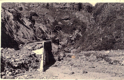
On the Eastern side of the island in the area known as “Hells Gate” which was far above sea level a legend was passed down about the settlers having to fight the native Kalinago for the use of the Spring at what became known as “Spring Bay”. According to this legend recorded in the book “Tales from My Grandmother’s Pipe” there was a “Great Injun” guarding the Spring and the settlers could not get past him. So they recruited a strong man named “Johnny Frauw” to engage the Great Injun in battle in order to get access to the Spring. The two men fought each other on “Fair Play Ridge” all day and ended up into the sea where both were drowned. If you look at the area on the back of Flat Point known as “Johnny Frauw’s Pond and see a blue light moving about it is his ghost looking to find the Great Injun. Later on, the Europeans secured the well and built it up for easier access. In the Alice flood of January 2nd, 1955, the Spring was filled up and never repaired. A well was dug later on and in the 1950’s Daniel Thomas Johnson and others renewed it and though not in use it still remains there. It would make sense to relocate the Spring and bring it back into use by also building a cistern next to it. This cistern could be used together with the necessary infrastructure to accommodate locals as well as visitors to the Island to camp out there.
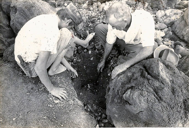

When the young Haitian historian Dantes Fortunat visited Saba in 1870 when Governor Moses Leverock was in function in the report on his visit to Saba, he described five springs along the island of which some were hot. We know for sure that there are two hot springs one below the cliffs between Tent Bay and the Ladder which may have been filled in by a large landslide some years ago. The other one is opposite the Green Island and the cliffs under the former Sulphur Mine. Two other Springs which were already mentioned are at the Fort Bay and the Spring Bay.
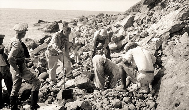
In the nineteen eighties a Venezuelan expert was asked by the Saba Government to check out the Springs and the possibility of finding more around Saba. According to him at the time he said that one could detect water flow from the mountain by the difference in colour of the water along the coast. And so, springs could be located.
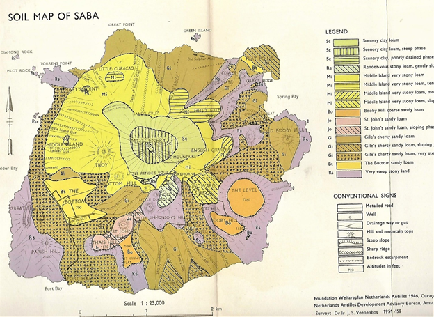
In 1951-52 Drs.J.S. Veenebos published a study he had made which is entitled “A Soil and Land Capability Survey of St. Maarten, St. Eustatius, and Saba with several very useful maps included. He gives some data for Saba from 1949 which is as follows.
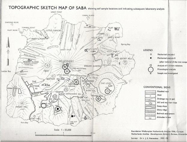
Saba
Spring Location Spring Bay sampling July 1949 Cl’mg/l 1410 Total hardness D039 pH8(?).
Spring Bay well. 7 meters deep Cl’mg/l 160 Total Hardness 19 and pH 7.5 (?).
Upper Mountain Water Hole Location: West of Hell’s Gate. Cl’mg/l – 35 Total Hardness Do7 and pH 7 and ¼.
Spring Fort Bay Cl’ mg/l 2000-3000 (estimate) and pH 8’
Warm Water Spring at beach North of Ladder Point. Date of sampling 15 March 1950. Cl’ mg/l 2084 – 2180 Total hardness 102-115 and pH 6.9 – 7.1.
He does not mention the Spring below the Sulphur Mine however that one also has been studied over the years.
Veenebos states the following on the use of cisterns as a solution to water shortages experienced from time to time. He states: “It is felt that underground cisterns could be constructed in St. Maarten, Saba and St. Eustatius, at no undue cost. It would be necessary, however to use cement or concrete, in order to provide good water-holding reservoirs. Each cistern would require its own special-lay out governed by the local situation, so as to insure maximum intake of water. In this way, water supplies could be made available to isolated settlement and plots. The water could be made available to isolated settlements and plots. The water could be pumped up with the help of small wind-mills or brought up with buckets.”
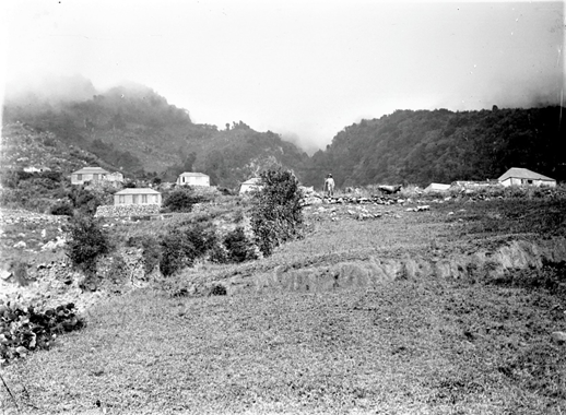
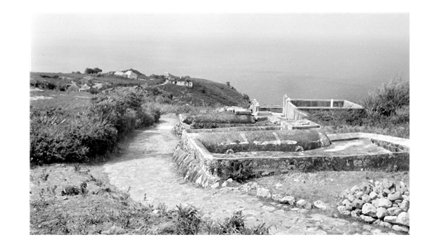
In the early nineteen fifties the Government built a cistern in Windward Side with a pipeline leading to the English Quarter with two places where you could get water by bucket. It served a very useful purpose for people living there back then. In the Bottom one was also built in the hillside above where the future Medical School is now situated. That one also had pipe lines to the town below. In recent years both have been restored with especially in The Bottom pipelines running to the hospital and the Government Administration Building.
Over the centuries there have been many times of water crisis because of droughts and hurricanes. In Kenneth Bolles book “Caribbean Interlude” on a visit to Saba, he mentions an old timer stressing the importance of The Mountain to the people of Saba. He states that “The Mountain she takes care o’ we.” Bobby Every in an interview said that his father had told him that if it was not for the mountain many people would have died in times of drought. Drought and its consequences were an ever-present concern on the minds of the people living on Saba throughout the centuries. Cisterns were built by those who had means to do so but not everyone could afford such. Water usage was limited to drinking, cooking and bathing. Every house nearly had a privy built away from the house which also saved on water supply.
In the past fifty years newly, built houses have relatively large cisterns. In some areas like The Level several homes have cisterns with capacity of over thirty thousand gallons of water.
And the need is still there to build cisterns. Writer of this document members when he was Lt. Governor a.i. giving a lift to a Medical Student on St. John’s. When he got in the car the first advice he gave was: “Never stop building cisterns.” He gave as argument seeing so many people in flooded areas like New Orleans and they were desperate for water as it was too polluted to drink even though you saw water all around. He said such a thing is unlikely to happen on Saba with individual cisterns to each house. Even with the most devastating hurricanes and removal of downspouts before the arrival of the hurricanes, nearly all water in cisterns on the island is fit to use.
Saba should always be aware of the need for cistern water and should not issue building permits for houses without cisterns and large ones at that.
Floods have also been a continuing occurrence causing costly damage. This could have been avoided by building large cisterns along the road, especially leading to the harbor at the Fort Bay. Cisterns would be able to take up a lot of the flood water going to the harbour before the water could reach there.
Cisterns could be built in front of the home of the Island Governor by temporarily removing the small parking lot and building over into the gut and a very large cistern at that. In the event of a hurricane and the cistern is full the water could be distributed or slowly drained out so the reservoir would be empty. The same could be done at the Back of the S-curve. Build another large cistern there, and another one on the left side of the road under the cliff. The large boulders could be taken out first from there and there would be enough room to build a large reservoir there as well.
The Yellow Fever mosquito campaign used to have a survey of all cisterns on Saba. This was in the nineteen seventies of all the cisterns on Saba. This could be looked into and updated by checking on abandoned cisterns all over the island, from Behind the Ridge to Below the Gap. A plan could be made in cooperation with the owners to have these cisterns repaired so they can be used again for use in agriculture and in case of fire.
The Government needs to spearhead a project which would include a survey of water catchments on the island as well as cisterns which are no longer in use and can be repaired.
Also check on the potential of the “Water Rock” close to “Santa Cruz”. There is/was a sort of Spring there. Perhaps this could be drilled somehow and have a pipeline underground leading to the water catchments along the road at Hell’s Gate.
In the past year (2020) Saba has been taught a hard lesson. We are grateful for all the help The Netherlands have been giving us then, now and before but we must strive as much as possible to be on our own with food production. Holland too and the rest of the world are going through troubling times which are negatively influencing their economies. Therefore Saba, with the help of The Netherlands, must do everything possible to have a good decentralized water supply in the form of cisterns at every home, and to have a secure food supply by encouraging agriculture as much as possible with a hope that enough can be produced even for export.
This report on my part has been prepared at the request of Commissioner Rolando Wilson for preparing the necessary technical research and plans for execution of these and other ideas which will come forward in this regard.

Done on this the 30th of January in the Year of Our Lord two thousand and twenty-one.
In duty bound shall forever pray:
William S. “Will” Johnson
